|
|
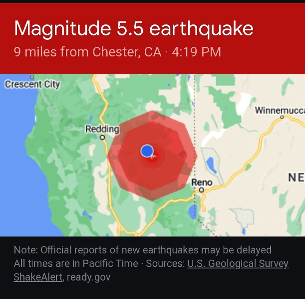
| Lake Almanor M 5.5 Earthquake - May 11, 2023 @ 4:19 PM | ||
|
Magnitude Time Location Coordinates Depth Modified Mercali Scale |
5.5 - Moment magnitude (USGS) Thursday afternoon, May 11, 2023 at 4:19:41 PM (PDT) 4 miles east of Prattville, 1 mile northeast of Rocky Point Campground 40.204°N, 121.110°W 5.9 km (3.67 miles) VI |
|
|
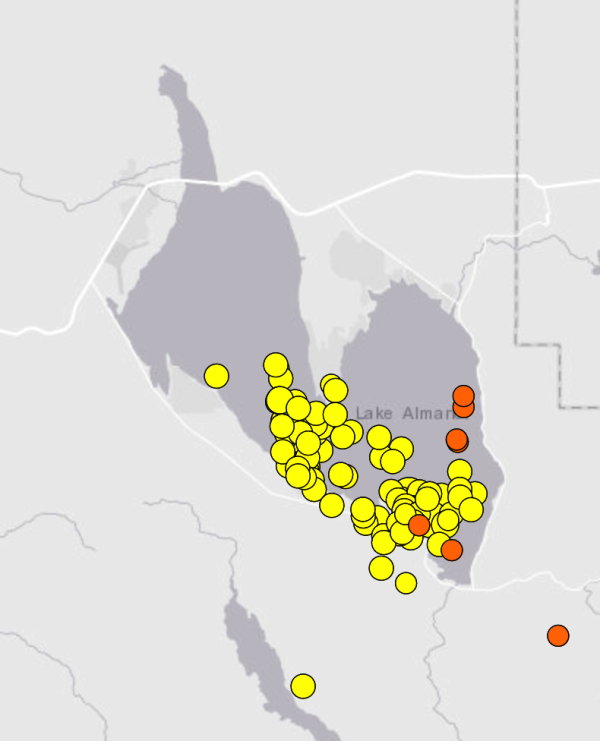
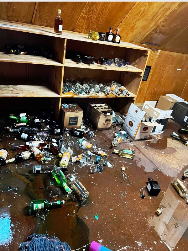
At 4:19:41 p.m., Thursday afternoon, May 11, a moderate earthquake measuring M 5.5 occurred about four miles east of Prattville and about a mile northeast of Rocky Point Campground, in Lake Almanor. The focal depth was about 3.67 miles (5.9 km) and the type of fault movement was normal-slip (down and away) with a slight oblique component. The orientation of the slip was north-northwest and the directivity is not well understood at this time. The earthquake was followed by a moderate aftershock sequence for the next 12 hours that included three quakes in the M 3 range, the largest of which measured M 3.8 at 7:54 p.m. that evening. Then at 3:18:41 a.m. Friday morning, a M 5.2 earthquake struck about a third of a mile northeast of Rocky Point Campground. The focal depth was about 3.79 miles (6.1 km) and the type of fault movement was normal-slip (down and away) with a with a prominent strike-slip component. As of noon on May 17, a total of 96 aftershocks measuring M 1.0 or stronger have been recorded, including four M 3s and the M 5.2 event. The frequency of aftershocks has waned, with the daily count showing May 11 @ 28, May 12 @ 34, May 13 @ 9, May 14 @ 9, May 15 @ 5, May 16 @ 7, and today, May 17 @ 4 – so far. The last M 3 measured M 3.2 and occurred at 4:37:26 on May 16. While no one can predict when earthquakes will occur, it is likely that the aftershocks will continue for several weeks. The earthquake was felt over a wide area, from Alturas, to Carson City, to Redding, and as far away as the San Francisco Bay Area. Light items were tossed from tables and shelves, pictures were knocked askew, and many people became excited and were genuinely frightened. Some dogs barked. Based upon the reports of damage from thousands of sources, the US Geological Survey has assigned a Modified Mercalli Intensity Scale of VI, which indicates a moderate earthquake. The hardest hit areas were located on the Lake Almanor Peninsula, Prattville, and the East Shore community where light items toppled, chandeliers swung, and security alarms were set off. Moderate damage was also reported in Chester, Canyon Dam, and Greenville. Holiday Market in Chester and Peninsula Market on the north shore of Lake Almanor reported their isles were littered with commercial items, including broken wine and liquor bottles, cereal boxes and other odds and ends. The largest loss was reported from The Plumas Pines restaurant and bar where numerous glass and liquor damage was reported. Overhead racks lost some glassware, liquor and wine bottles from bar shelves spilled out, and other commercial items were dumped to the floor. No broken picture windows have been reported and there were no reports of serious injuries besides some minor cuts and scratches and many frayed nerves. Only some light objects were tossed to the aisle in the store at Pizza at the Branch. Carol’s Restaurant lost some dishware and glasses, and a large container of maple syrup toppled making a sticky mess all over the kitchen floor. The Chester Chamber of Commerce’s Mixer at Carol’s continued without a hitch, but the earthquake and everyone’s reports were the talk of the evening. One person fishing on the East Shore at the time of the M 5.5 quake said the fishing was poor all day but once the quake happened, the fish were again biting and then fishing was outstanding. He described the shaking as though there were tiny vigorous vibrations slapping against the boat. He was not sure what was happening until a woman on shore raking her lawn starting shouting “Earthquake!” and began waving her arms and running all about. There has been a plethora of rockfalls, including a car-size rock toppling from its cliff above Highway 89 between Prattville and Rocky Point Campground. Other large rock falls occurred on Highway 147 near Clear Creek and one at the bottom of Johnson Grade on Highway 36. CalTrans has pushed most of these rocks off to the side and/or placed hazard signs along the highway. The Seneca Road was also littered with rocks. PG&E has checked on the Lake Almanor and Butt Reservoir Dams and has not observed any signs of damage or compromise. There was no new activity at Mount Lassen as a result of the earthquake. The aftershock pattern shows two distinct clusters of earthquakes, one in and around the two The eastern cluster are clearly aftershocks to the two main M 5 earthquakes. Further examination shows there is likely a more complex geologic condition happening. The fault slip for both M 5 events were predominantly normal (down and away) motions suggesting that the lake may have gotten deeper and wider. The fault planes were north-northwest and west-northwest suggesting they occurred along different tectonic structures. Most of the seismic activity is happening on both structures, plus other nearby structures. It lends to an impression the activity is acting like a shattered windshield with little movements happening on smaller structures. The western cluster off the coast of Prattville and the southwest shore of the Almanor Peninsula is a distinct trend that parallels the Almanor Fault Zone. This prominent north-northwest-trending fault zone extends from Prattville, up the west shore of the Almanor Peninsula, through the North Shore Campground, and into Lassen Volcanic National Park and beyond. There are two main splays, a west and an east splay. Both have significant vertical displacements on the order of 40-plus feet, some of which have occurred in the last 13,000 years and has a total of a few hundreds of vertical feet indicating this is an old long-lived prominent fault zone. These data suggests that the Almanor Fault Zone as a whole is capable of producing earthquakes in the upper M6s to low M 7s ranges. What is striking about the recent western pattern of aftershocks is that they form a trend that coincides with the southern-most portion of the Almanor Fault Zone where it intersects with the much larger northwest-southeast-trending Mohawk-Almanor-Lassen Fault Zone. This fault zone is the “bad boy” on the block. It extends from south of Sierra Valley, through Mohawk Valley and Quincy (American Valley), through Indian Valley and by the west shore of Lake Almanor, and into the Lassen Volcanic Center. It is capable of producing earthquakes in the upper M6s to mid M 7s ranges. The third collection of aftershocks appears to be related to activity on the Mohawk-Almanor-Lassen Fault Zone. The intersection of these two fault zones or how they influence one another is not well understood, and likely has never been postulated until now that it seems important. Nevertheless, seeing this many aftershocks on these potentially large-magnitude fault zones is disturbing. Movements on segments of these fault zones cause more stress on the segments that are not moving. Reassuring is that this activity happens in geologic time and that one must look at the bigger picture when reviewing this seismic activity. Watch the USGS recent Activity web page and take the appropriate actions if you deem necessary. What would be the best outcome is that the seismic activity would subside and we can relax. If you are in the Lake Almanor – Greenville area, please be advised to take your earthquake preparedness seriously. Aftershocks are likely to continue for a while and some may be as strong or stronger than the main shock. Be advised to have extra food and medical supplies, take care of children and the elderly, and be alert when driving in the mountains, as rocks could tumble off the roadside cliffs at anytime. If you feel the ground begin to shake, move back from picture windows and cabinets, stay away from the shoreline, and use the tried and true earthquake preparedness slogan: LOOK – Look at your safety options. Your first move can save your life. DUCK – Move and duck under a shelter. COVER – Put your hands over your head to protect yourself. HOLD – Latch onto your cover and hold on. Move with it if it moves. When the shaking stops, remember to check on children, the elderly and your pets. If you have photos that you would like to share, please send to Charles Watson. |
||
|
Holiday Market
(Photo by Jennifer Armenta-Lawson)

Plumas Pines Resort
(Photos by Plumas Pines)


Peninsula Market
(Photos by Lisa Turner)


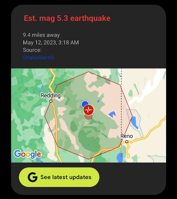
| Lake Almanor M 5.2 Earthquake - May 12, 2023 @ 3:18 AM | ||
|
Magnitude Time Location Coordinates Depth Modified Mercali Scale |
5.2 - Moment magnitude (USGS) Friday morning, May 12, 2023 at 3:18:41 AM (PDT) About 1/3 of a mile northeast of Rocky Point Campground 40.196°N, 121.100°W 6.1 km (3.79 miles) VI The M 5.3 was a preliminary magnitude that was adjusted to M 5.2. |
|
|
|
|
|