|
|
| Placer Mining Claims For Sale | |||||||||||||||||||||||||||||||||||||||||||||||||||||||||||||||||||||||||||||||||||||||||||||||||||||||||||||||||||||||||||||||||||||||||||||||||||||||||||||||||||||||||||||||||||||||
|
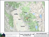
Lucky Schneider #1 - #4 ±220 Acres Price: $20,000 Little Schneider Creek drains a large plateau of Tertiary gravels that forms the divide between the North and Middle Forks of the Feather River. The Rich Bar Fault, the western boundary of the Feather River Serpentine Unit, cuts through Little Schneider Creek in its headwaters. Both the fault, the serpentine and the meta-sedimentary rocks adjacent to the fault are noted for rich pockets of gold. Our Lucky Schneider #1 - #4 placer mining claims secures the upper reach of the Little Schneider Creek. The gold is bright and plentiful! It is both rounded (Tertiary gravel source) and chunky (nearby bedrock source).
These pictures were taken in October and show a pretty good flow. There are a number of gravel bars, pools and ledges that will provide many opportunities. Notice the the creek flows on bedrock in many of the photos. The snow usually melts off in early June. High bankers will have a field day with all the opportunities adjacent to the creek. The pools are relatively shallow and air is not required to reach the bedrock. Hence, the required prospecting skills are recreation to intermediate. Advanced miners who like to tackle the smaller creeks will equally enjoy this claim's abundant opportunities, especially with all the bedrock exposures! There is good access to the creek to Little Schneider Creek. There is a good camp site on the claim for a fifth-wheel or camper; probably not a motor home friendly. There are a number of tent camping spots too. Miners and prospectors will have a life-time of opportunities before this claim is played out. This spot is one of a kinda and you will want to add this claim to your portfolio. Estimated GPS Coordinates:
Click here Google Earth Fly To and see an aerial photo of Lucky Schneider #1 and the claim boundaries. Google map it for directions to claim. Estimated GPS Coordinates:
Click here Google Earth Fly To and see an aerial photo of Lucky Schneider #2 and the claim boundaries. Estimated GPS Coordinates:
Click here Google Earth Fly To and see an aerial photo of Lucky Schneider #3 and the claim boundaries. Estimated GPS Coordinates:
Click here Google Earth Fly To and see an aerial photo of Lucky Schneider #4 and the claim boundaries. Standard Information Upon payment, the mineral claims will be transferred via a notarized Quitclaim notice filed in your name with Plumas County and the BLM. A $150 fee is assessed to handle the transfer. Limited payment terms and conditions are available; information available on request. Advanced Geologic has an exceptional automatic claim notice filing system that will maintain your annual filings for any claim in the United States. Advanced Geologic reminds you that you MUST file annual notices with both the county in which the claim is located AND with the Bureau of Land Management by the appropriate dates. There are NO exceptions and errors will lead to the loss of your claim! Are your claims filed correctly? Advanced Geologic is a professional geologic consulting firm located in Chester, California. We not only sell quality mining claims, but we also help people work their claims. Our experience in resource evaluations, compliance and permitting and claim portfolio management allows our clients and buyers to go for the GOLD. Interested? Send us an email or call.
|
|
||||||||||||||||||||||||||||||||||||||||||||||||||||||||||||||||||||||||||||||||||||||||||||||||||||||||||||||||||||||||||||||||||||||||||||||||||||||||||||||||||||||||||||||||||||||
|
|
|
||||||||||||||||||||||||||||||||||||||||||||||||||||||||||||||||||||||||||||||||||||||||||||||||||||||||||||||||||||||||||||||||||||||||||||||||||||||||||||||||||||||||||||||||||||||
|
|


