|
|
| Canyondam M 5.7 Earthquake - May 23, 2013 @ 8:47 p.m. | ||
|
Magnitude Time Location Coordinates Depth Modified Mercali Scale |
5.7 - Moment magnitude (USGS) Thursday evening, May 23, 2013 at 8:47:08 PM (PDT) 11 miles northwest of Greenville, 1.5 miles northeast of Canyondam 40.190°N, 121.061°W 11.05 km (6.8 miles) VII |
|
 |
||
|
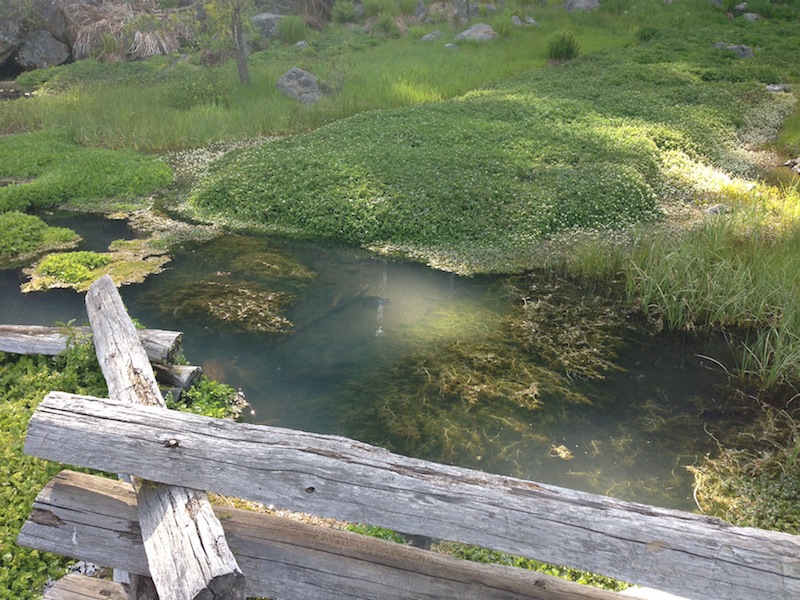
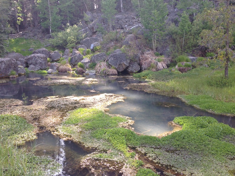
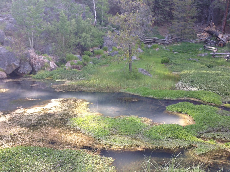
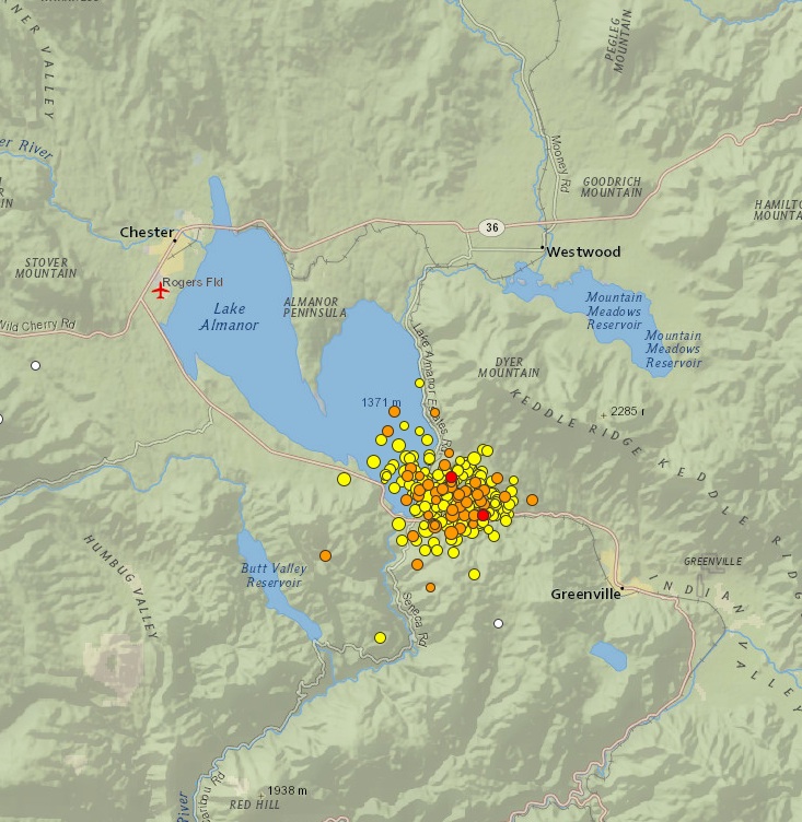
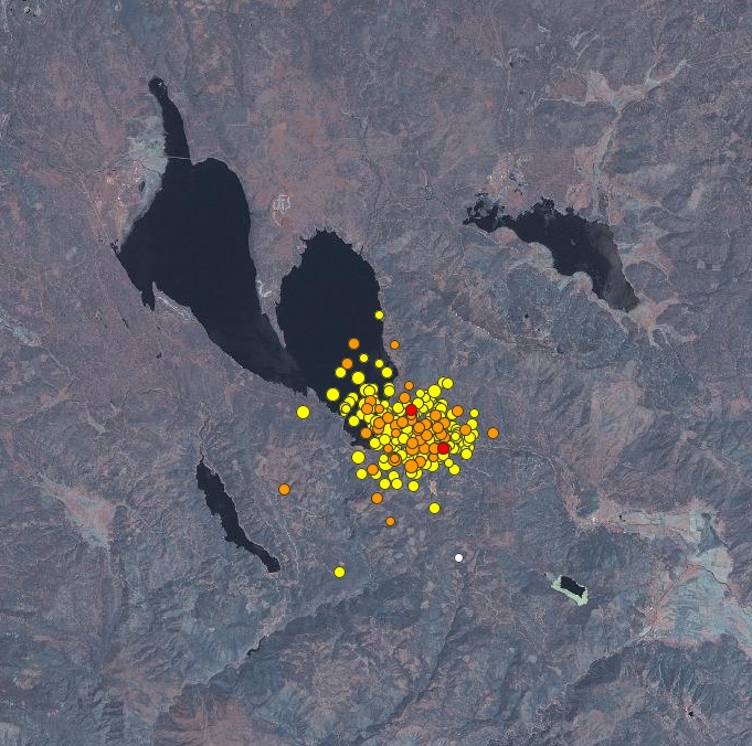
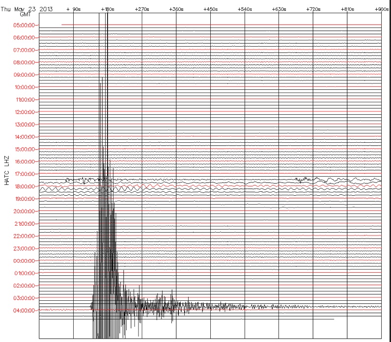
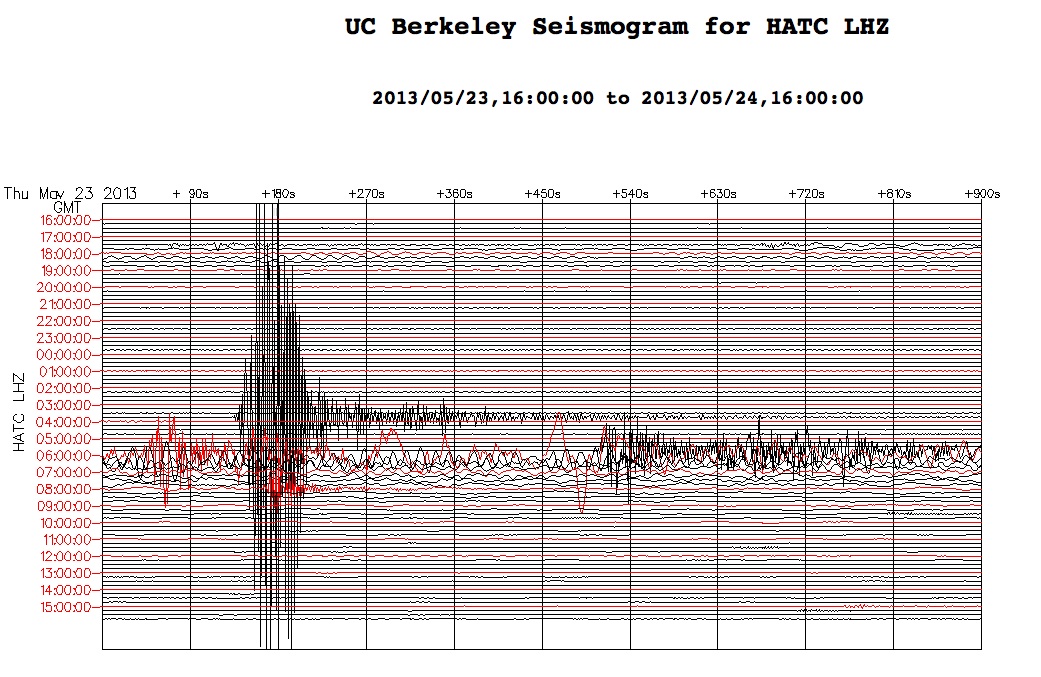
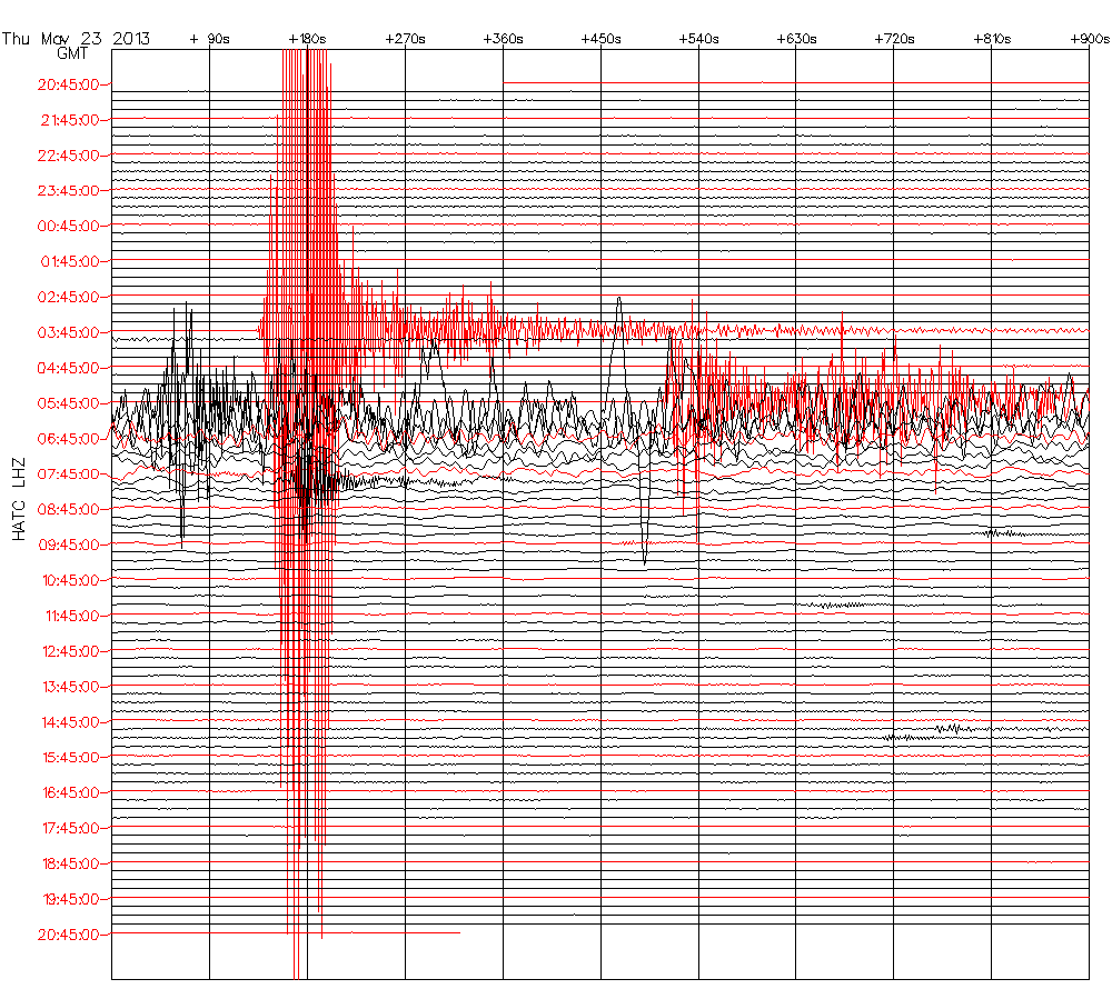
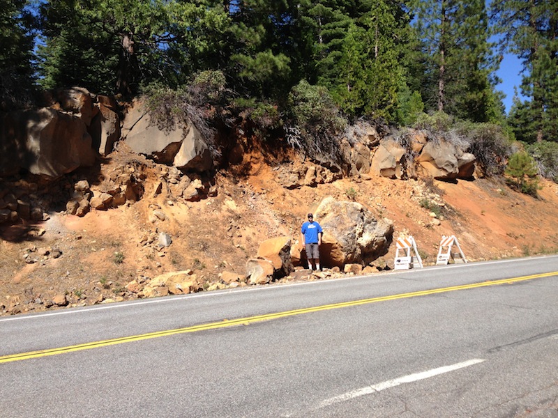
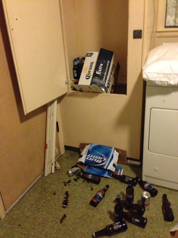
At 8:47 p.m., Thursday evening, May 23, a moderately strong earthquake measuring M 5.7 occurred about 11 miles northwest of Greenville and 1.5 miles northeast of Canyondam, in a remote area a mile east of Lake Almanor. The focal depth was about 6.8 miles and the type of fault movement was strike-slip with a slight oblique component. The orientation of the slip is likely to be west-northwest and the directivity is likely up and to the west from the hypocenter (the point of rupture origin at depth). As of noon on May 25, a total of 266 aftershocks have been recorded, including four M 4s and 25 M 3s. The largest aftershocks measured M 4.9 (1:02 a.m., May 24), M 4.6 (8:49 p.m., May 23 – two minutes after the main shock), M 4.2 (8:50 p.m., May 23 – three minutes after the main shock), and M 4.0 (2:43 a.m., May 24). The most recent M 3+ event measured M 3.5 and occurred at 11:45 a.m. May 25. The frequency of aftershocks has waned, however, they still keep coming! The earthquake was felt over a wide area, from Klamath Falls, to Fallon, to Yosemite and to the SF Bay Area. Items were tossed from tables and shelves, pictures were knocked from walls and many, many people became excited and were genuinely frightened. Based upon the reports of damage from thousands of sources, the US Geological Survey has assigned a Modified Mercalli Intensity Scale of VII, which indicates a moderately strong earthquake. The hardest hit areas were located on the Lake Almanor Peninsula, Prattville, and the West Shore community where pantries emptied, items were tossed from tables and shelves and pictures were shaken from the walls. Some large pieces of furniture and appliances moved several inches from their original positions. There were numerous reports of light items toppling, chandeliers swinging and security alarms being set off. There are some reports of pipes breaking and resulting water damage. Some chimneys were knocked from roofs. Moderate damage was also reported in Greenville and Crescent Mills, and other parts of Indian Valley. Light damage was reported from Chester, Westwood and Quincy. There was a report of over 200 calls to a single insurance agent of damage. Holiday Market in Chester and Evergreen Market in Greenville reported their isles were littered with commercial items, including broken wine and liquor bottles, cereal boxes and other odds and ends. The largest loss was reported from The Pines restaurant and bar where over $4,000 of glass and liquor damage was reported. Drink glasses from three overhead racks emptied, liquor and wine bottles from bar shelves spilled out and other commercial items were dumped to the floor. Fortunately, the restaurant and bar were not open on Thursday night, else injuries would likely have occurred. No broken picture windows have been reported and there were no reports of serious injuries besides some minor cuts and scratches and many frayed nerves. Considering the quake occurred on the cusp of the Memorial Day Holiday, numerous tourists were in the area or on route the following day. There are reports that some have left because of the earthquake. Others are very wary about staying, fearing more aftershocks or another moderate or large shock. There have been a plethora of rockfalls, including a truck-size rock topping from its cliff above Highway 89 between Pratteville and Rocky Point Campground. CalTrans has placed hazard signs along the highway. The Seneca Road was littered with rocks. There are reports of seiche on Lake Almanor that reached as high as 1.5 to 2 feet. Some sand bars were piled up on the southeast shoreline near the dam. PG&E has checked on the Lake Almanor and Butt Reservoir Dams at lease twice and has not observed any signs of damage or compromise. Surface pebbles along the southeast shore of Lake Almanor showed a vertical acceleration whereby they left the ground during the earthquake and came down in aside of their original location, leaving an exposed depression. Many rocks along the shoreline cliffs dislodged and tumbled to the beach. The Canyondam M 5.7 earthquake occurred on the Mohawk Valley – Lake Almanor fault zone, a prominent zone of faults that occur on the northern margin of the Sierra Nevada and extend from southern Sierra Valley to the Lassen Volcanic Center. Some of the faults have been studied and evaluated to be capable of maximum earthquakes in the upper M 6s to low M 7s, but most have not or lack quality exposures and opportunities for technical evaluation. Some are obviously Holocene in age (<13,000 years old) and some of these have moved with large earthquakes at least two or three times. Some of the Holocene displacements are on the order of 5-10 meters (15-30 feet), which clearly suggests large earthquakes have occurred on those faults more than once. Quality seismological monitoring of the region did not happen till the early 1970s and location of moderate to large earthquakes prior to that was relatively crude. Most of them occurred on the eastern side of the Sierra in the Reno – Carson City corridor, but there were a few in the northern Sierra. It was in the early 1930s when seismographs began recording earthquakes in California and since then, 26 earthquakes registering M 5.0 or greater have occurred in the region, three in the M 6 range – none larger than M 6.1. The largest since the 1960s and occurred a few miles east of Truckee at Boca Dam and measured M 5.9 – M 6.0. In 1975, the Lake Oroville M 5.7 earthquake caused some minor surface fault ruptures that nearly extended into the Oroville Dam. Since 1998, there have been five earthquakes registering M 5.0 or stronger. The most recent prior to the Canyondam quake happened on October 27, 2011 and was center two miles north of Quincy at Quincy Junction. Also noteworthy and located within the Mohawk Valley fault zone was a M 5.1 on November 26, 1998 just north of Graeagle at Mt. Tomba. It is likely numerous earthquakes were associated with the Lassen Peak eruption of 1914 – 1917, but there are no records of any measuring larger than M 5.0. There are unconfirmed reports of springs around the mountain showing increased turbidity (cloudy sediment) from the Canyondam earthquake, including those at Domingo Springs. Advanced Geologic will be leading a team of experts to observe and sample both cold and hot water springs there and in Lassen Volcanic National Park. It should be noted that the Canyondam earthquake was caused by tectonic forces unrelated to magma under the Lassen Volcanic Center, however, the shaking could have had some influence on the groundwater reservoir and its conduits. It is common for groundwater wells to show turbidity following a significant earthquake. Periodic purging of the water should quickly clean this up. If you are in the Lake Almanor – Greenville area, please be advised to take your earthquake preparedness seriously. Aftershocks are likely to continue for a while and some may be as strong or stronger than the main shock. Be advised to have extra food and medical supplies, take care of children and the elderly, and be alert when driving in the mountains, as rocks could tumble off the roadside cliffs at anytime. If you feel the ground begin to shake, move back from picture windows and cabinets, stay away from the shoreline, and use the tried and true earthquake preparedness slogan: LOOK – Look at your safety options. Your first move can save your life. DUCK – Move and duck under a shelter. COVER – Put your hands over your head to protect yourself. HOLD – Latch onto your cover and hold on. Move with it if it moves. When the shaking stops, remember to check on children, the elderly and your pets. If you have photos that you would like to share, please send to Charles Watson. |
More Photos shortly.
|
Domingo Springs. Notice slightly cloudy appearance.
|
|
|
|